Scott's Map of the Consolidated City of Philadelphia, 1856, Map
Maps 1856: Scott & Moore, Map of the Consolidated City of Philadelphia
Item Info
Page: 1
Work Type: Property Atlases/Maps
Source: Map Collection
Notes:
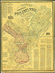
Blunden's Cotton Factory: Darby Creek at village of Paschalville (24th Ward)
Brugg's Paint Works: Philadelphia & Trenton Railroad in village of Frankford (23rd Ward)
Buist's Nursey: South of Mt. Moriah Cemetery (24th Ward)
Carr's Pleasant Mills: above Cresheim Creek west of Germantown Road (22nd Ward)
City Tavern: between Hog Island and Philadelphia, Wilmington & Baltimore Railroad (24th Ward)
Crease's Chemical Works: Crease's Lane east of Ridge Road (21st Ward)
Fountain Abbey: Comley's Road south of village of Mechanicsville (23rd Ward)
General Wayne Tavern: Pennypack Creek above village of Holmesburg (23rd Ward)
Hamburg Hotel: Schuylkill River below city gas works (1st Ward)
Hiller's Ax Factory: south of Vereeville (23rd Ward)
Hinkle's Mill: Cresheim Creek west of Germantown Road (22nd Ward)
Horner's Varnish Factory: Venango and Front Streets (23rd Ward)
Jackson Tavern: between Hog Island & Philadelphia, Wilmington & Baltimore R.R. (24th Ward)
Large's Print Works: Tacony Creek above village of Frankford (23rd Ward)
Lippen's Hotel: Wissahickon Creek above School House Lane (21st Ward)
McCallum Cotton Factory: Carpenter Street west of Germantown Road (22nd Ward)
Oxford & Lower Dublin Poorhouse: Pennypack Creek above village of Holmesburg (23rd Ward)
Passmore Mills: Darby Creek at village of Paschalville (24th Ward)
Pennypack Print Works: Pennypack Creek above village of Holmesburg (23rd Ward)
Penrose Ferry Hotel: Ferry Road and Schuylkill River (24th Ward)
Point Breeze Hotel: Schuylkill River below city gas works (1st Ward)
Red Lion House: Poquessing Creek at Bristol Turnpike (Bucks County)
Rising Sun Inn: 53rd Street south of West Chester Railroad (24th Ward)
Rowland Bros. Rolling Mills: Louden Street west of village of Frankford (23rd Ward)
Rowland Bros. Spade and Shovel Works: Pennypack Creek above Holmesburg (23rd Ward)
Smithfield Hotel: Horsham Road & Bustleton Turnpike in village of Somerton (23rd Ward)
Somerton Hotel: Horsham Road & Bustleton Turnpike in village of Somerton (23rd Ward)
Sorrel Horse Tavern: Ridge Road above Ship Lane (21st Ward)
Union Tavern: village of Bustleton (23rd Ward)
Wheat Sheaf Tavern: Bustleton & Somerton Turnpike below village of Sandford (23rd Ward)
Whitaker's Cotton Factory: Plank Road above village of Frankford (23rd Ward)
White Swan Hotel: Allen's Lane and Germantown Road (22nd Ward)
Northside Orientation of Image: Top
Alternate Page Number: Map
City/Town/Township: Geographic Coverage Ward:25th Ward
Geographic Coverage State/Province:Pennsylvania
Geographic Coverage City/Town/Township:Philadelphia
Creator Name: Scott & Moore - Publisher
- Axes
- Paint
- Philadelphia, Pennsylvania
- Shovels
- Taverns
- Hotels
- Abbeys (monasteries)
- Chemical plants
- Textile mills
- Spades
- Flour mills
- Almshouses (buildings)
- Oxford & Lower Dublin Poor House
- Divisions (political administrative bodies)
- Wards
- Paints & varnishes
- Varnishing industry
- Whitaker, William-Cedar Grove Mill
- Rowland Bros. Spade & Shovel Works
- Rising Sun Hotel
- Cotton mills
- Nurseries (horticulture)
- Poorhouse see Almshouses (buildings)
- Crease's Chemical Works
- Rolling mills
- Grist mills see Flour Mills
- Large's Dye Mill
- Carr's Cotton Factory
- Hinkle's Grist Mill
- Red Lion Tavern
- General Wayne Tavern
- Wheat Sheaf Tavern
- Sorell Horse Tavern
- White Swan Hotel
- Jackson Tavern
- City Tavern
- Buist's Nursery
- Passmore's Mill
- Blunden's Cotton Factory
- Rowland Bros. Rolling Mills
- Hamburg Hotel
- Point Breeze Hotel
- Penrose Ferry Hotel
- McCallum's Cotton Factory
- Brugg's Paint Works
- Horner's Varnish Factory
- Union Tavern
- Hiller's Ax Factory
- Smithfield Hotel
- Somerton Hotel
- Fountain Abbey
- Lippen's Hotel
 Map
Map