
Item Info
Page: 1
Work Type: Street Maps
Source: Map Collection
Notes:
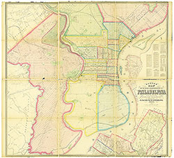
2nd & 3rd Street Railroad Station: east side Frankford Road below Lehigh Avenue (top right)
5th & 6th Street Railway Station: 4th Street & Montgomery Avenue (top center)
10th & 11th Street Railway Station: northwest corner 10th Street & Montgomery Ave. (top center)
Academy of music: southwest corner Broad & Locust Streets (top center)
Academy of Natural Sciences: northwest corner Broad & Sansom Streets (top center)
American Mechanics Hall: Ridge Road in Andora (lower center-Roxborough)
Aramingo Chemical Works: North York Railroad below Erie Avenue (top right)
Arch Street Railway Station: south side Callowhill Street below wire Bridge (top center)
Assembly Building: west side 10th Street below Market Street (top center)
Athenaeum of Philadelphia: east side 6th Street below Walnut Street (top center)
Avenue Drove Yard: Florida Street opposite Olive Cemetery (top left)
Bisoat, G. Planing Mill: Delaware Avenue above Shackamaxon Street (top right)
Blockely Almshouse: west side Schuylkill River below Darby Road (top center)
Blue Bell Tavern: west side Cobbs Creek above Darby Road (lower left-Delaware Co., Darby T.)
Blunden's Mill: Mill Creek above Haverford Road (top left)
Bull's Head Drove Yard: 65th & Oregon Streets (top left)
Burd Orphan Asylum: Powell Street & Westchester Road: (Delaware County-top left)
Buttonwood Tavern: Ridge Road & Green Tree Lane (lower center-Roxborough)
Byberry Hall: in Byberry (lower right)
Cheltenham Nursery: Cheltenham Township (lower right)
Chestnut & Walnut Street Railroad Station: 21st & Sansom Streets (top center)
Christ Church Hospital: Dauphin to York Streets between 48th & 50th Streets (top left)
Citizens Passenger Railway Station: east side 10th Street below Columbia Bridge (top center)
City Tavern: Eastwick & 88th Streets (lower left)
Classical Institute: near 13th & Spruce Streets (top center)
Continental Theatre: north side Walnut Street above 8th Street (top center)
County Line Inn: Old York Road in Chelten Hills (lower right-Cheltenham Township)
County Prison: Passyunk Road at Reed Street (lower center)
Cramp Shipyard: Delaware Avenue below Ash Street (top right)
Darby Railroad Station: Darby Road below 33rd Street (top center)
Delaware Reservoir: northeast corner 7th Street & Lehigh Avenue (top center)
Dyottville Glass Works: Delaware Avenue at Gunners Run (top right)
Eastern Market: east side 5th Street below Market Street (top center)
Eden Hall Seminary: east of Torresdale (lower right)
Episcopal Hospital: southeast corner Front Street & Lehigh Avenue (top right)
Fairmount Gas Works: south side Callowhill Street at 25th Street (top center)
Fairmount Market: northeast corner Spring Garden Street & Pennsylvania Avenue (top center)
Fox Chase Hotel: Fox Chase (lower right)
Franklin Institute: east side 7th Street below Market Street (top center)
Germantown Waterworks: Wissahickon Road at Washington Street (lower center-Germantown)
Gillingham & Garrison Lumber yard (top right)
Girard Bank: west side 3rd Street below Chestnut Street (top center)
Grant, J.C. Stone Yard: east side Schuylkill River at Spruce Street (top center)
Harrowgate Hotel: Frankford & Kensington Road at Harrowgate Lane (top right)
Healey's Cherry Hotel: Christian Avenue & 46th Street (top left)
Hermitage: Wissahickon Creek at Hermit's Lane (lower center-above Falls of Schuylkill)
Hestonville, Fairmount & Mantua Railroad Station: 52nd Street & Lancaster Avenue (top left)
House of Industry: south side Catharine Street above 7th Street (top center)
House of Refuge: Parrish Street to Poplar Street between 22nd & 24th Streets (top left)
House of the Good Shepherd: east side 22nd Street above Walnut Street (top center)
Howard Institution: southeast corner Ridge Avenue & Poplar Street (top center)
Hunter's Calico Print Works: northwest corner 55th & Paschall Street (top left)
Hunter's Mill: southeast corner 55th Street & Haddington Street (top left)
Kensington Bank: Beach Street below Frankford Road (top right)
Kensington Waterworks: Delaware Avenue above Berks Street (top right)
Keyser & Ware Saw Mill: Delaware Avenue above Shackamaxon Street (top right)
Kingsessing Hotel: Philadelphia & Darby Plank Road below 53rd Street (lower left)
Lafayette Hotel: Ridge Road & Eliza's Lane (lower center-Roxborough)
Lombard & South Street Railroad Station: north side South Street at 21st Street (top center)
Lower Dublin Academy: Byberry Road & Bristol Turnpike near Collegeville (lower right)
Magdalen Asylum: east side 21st Street above Race Street (top center)
Manatawna School: Ridge Road in Andora (lower center-Roxborough)
Maupay's Nursery: Broad Street & Allegheny Avenue on Gunner's Run (top center)
Megargee's Mill: Wissahickon Creek at Township Line Road (lower center-Roxborough)
Monroe Engine House: 50th Street & Lancaster Avenue (top left)
Mechanics Hall: northeast corner $th & George Streets (top center)
Mechanics Hall: west side 3rd Street below Green Street (top center)
Moyamensing Hall: south side Christian Street above 8th Street (top center)
Musical Fund Hall: south side Locust Street above 8th Street (top center)
North American Hotel: Fox Chase Turnpike & Township Line Road (lower right)
Northern Home For Friendless Children: northeast corner 23rd & Brown Streets (top center)
Northern Liberty Gas Works: Cohocksink Creek below Laurel Street (top right)
North Pennsylvania Railroad Station: northeast corner Front & Willow Streets (top right)
North Philadelphia Railway Station: 3rd Street & Montgomery Avenue (top center)
Oddfellows Hall: northwest corner 3rd & Brown Streets (top center)
Oddfellows Hall: east side Broad Street below Spring Garden Street (top center)
Oddfellows Hall: west side 6th Street above Cherry Street (top center)
Oxford & Dublin Poorhouse: near Pennypack Creek above Hollinsville (lower right)
Oxford Race Course: Dungan Road & Township Line Road near Fox Chase (lower right)
Park Hotel: 52nd Street & Lancaster Avenue (top left)
Passmore Mill: Cobbs Creek at 75th Street (lower left)
Penn Steam Engine & Boiler Works: Delaware Avenue above Hanover Street (top right)
Pennsylvania Bank: west side 2nd Street above Walnut Street (top center)
Pennsylvania Hospital For the Insane: north side Market Street at 49th Street (top left
Pennsylvania Inst. for the Deaf & Dumb: northwest corner Broad & Pine Streets (top center)
Pennsylvania Inst. For the Instruction of the Blind: west side 20th St. above Race St. (top center)
Pennsylvania Medical College: west side 9th Street above Spruce Street (top center)
Pennsylvania Seamen's Friendship Society: northwest corner Front & Lombard Sts. (top center)
Pennsylvania State Arsenal: southeast corner 16th & Filbert Streets (top center)
Pennypack Print Works: Pennypack Creek at Harrisburg (lower right)
Philadelphia & Reading Railroad Station: east side Broad St. at Pennsylvania Ave. (top center)
Philadelphia & Reading Railroad Station: northeast corner Beach & Willow Streets (top right)
Philadelphia city arsenal: Juniper Street to Broad Street below Race Street (top center)
Philadelphia, Germantown & Norristown R.R. Station: east side 9th St. at Wallace St. (top center)
Powers & Weightman Chemical Works: East Falls (top center)
Prince's Mill: Pennypack Creek above Vereeville (lower right)
Race & Vine Railway Station: south side Callowhill Street below wire bridege (top center)
Ridge Avenue Passenger Railway: northeast corner 23rd Street & Columbia Avenue (top center)
Rittenhouse Mill: Wissahickon Creek at Shur's Lane (lower center-above Falls of Schuylkill)
St. John's Orphan Asylum: Westminster to Wyalusing Sts. bet. Kingsessing & 50th Sts. (top left)
St. Joseph's Hospital: south side Girard Avenue between 16th & 17th Streets (top center)
St. Vincent Orphan Asylum: Delaware River in Tacony (lower right)
Saunders Institute: 39th & Filbert Streets (top left)
Schuylkill Hose House: 12th & Locust Streets (top center)
Simpson's Wool & Cotton Mill: w. side Schuylkill Riv. above City Ave. (Montgomery County-top left)
Simpson & Neal's Shipyard: Delaware River below Swanson Street (lower right)
Smithfield Hotel: Horsham Road in Smithfield/Somerton (lower right)
Somerton Hotel: Horsham Road in Smithfield/Somerton (lower right)
Southwark & Richmond Railroad Station: west side Richmond St. above Lehigh Avenue (top right)
Southwark Hose Co.: northwest corner 3rd & Gaskill Streets (top center)
Southwark Planing Mill: Washington Avenue & Swanson Street (lower right)
Sportsman's Hotel: Island Road at Hollander's Creek (lower center)
Spring Garden & Northern Liberties Waterworks: Fairmount Park above Girard Bridge (top middle)
Spruce & Pine Street Railroad Station: west side 22nd Street below Spruce Street (top center)
Sunday School Union: south side Chestnut Street below 12th Street (top center)
Teedyuscung Wool & Cotton Mill: Wissahickon Creek at Paul's Mill Ln. (lower center-Chestnut Hill)
Union Drove Yard: Pennsylvania Railroad below 32nd Street (top middle)
Union Hose Co.: southeast corner 36th & Grape Streets (top middle)
Union Market: northeast corner St. John & Callowhill Streets (top middle)
Union Railway Station: northwest corner 23rd & Hare Streets (top middle)
Union Railway Station: southeast corner Thompson & Norris Streets (top right)
United States Naval Hospital: Humes Avenue below South Street (top center
United States navy Yard: Delaware River below Washington Avenue (lower right)
Wagner Free Institute: southwest corner 7th Street & Montgomery Avenue (top middle)
Walnut Mill: Pennypack Creek above Vereeville (lower right)
Walnut Street Theatre: northeast corner 9th & Walnut Streets (top middle)
Washington Engine House: north side Lombard Street below 11th Street (top center)
Waters, J. Mill: Indian Creek at Jefferson Street (top left)
West Chester & Philadelphia Railroad Station: south side Filbert St. above 31st St. (top center)
West Philadelphia Fire Engine Co.: north side Market Street above 44th Street (top center)
West Philadelphia Institute: 39th & Filbert Streets (top center)
West Philadelphia Railroad Station: northwest corner 41st & Haverford Streets (top left)
West Philadelphia Waterworks: west side Schuylkill River below Westminster Street (top center)
Western Market: northeast corner 16th & Market Streets (top center)
Wheat Sheaf Hotel: River Road & Bustleton/Somerton Turnpike (lower right)
Willbank Factory: west side Cobbs Creek above Naylor's Run (Delaware County-top left)
Wills Hospital: south side Race Street above 18th Street (top center)
Woodward's Snuff Factory: Cobbs Creek above Snyder Avenue (lower left)
Yewdell's Facory: northeast corner 55th Street & Girard Avenue (top left)
Northside Orientation of Image: Top
Alternate Page Number: Map
City/Town/Township: Geographic Coverage State/Province:Pennsylvania
Geographic Coverage City/Town/Township:Philadelphia
Creator Name: Barnes, Rufus L. - Publisher
Hexamer, Ernest - Surveyor
- Calico
- Philadelphia, Pennsylvania
- Powers & Weightman
- Railroad stations
- Street railroads
- Waterworks
- Wagner Free Institute of Science
- Steam engines
- Chemical industry
- Railroads
- Boilers
- Wool industry
- Glass industry
- Taverns
- Hotels
- Banks
- Markets
- Academy of Natural Sciences of Philadelphia
- LaFayette Hotel
- Academy of Music
- Music halls
- Theaters
- Reservoirs
- Philadelphia & Reading Railroad Co.
- Western Market
- Walnut Street Theatre
- Hospitals
- Pennsylvania State Arsenal
- Schools
- Stones
- Orphanages
- Megargee Paper and Rags (Firm)
- Blind (people)
- Pennsylvania Institution for the Deaf and Dumb
- Fire stations
- Street railroad stations
- Magdalen Society
- Pennsylvania Institute for the Instruction of the Blind
- Philadelphia Gas Works
- Assembly halls
- Wills Hospital
- Shipyards
- Fairmount Market
- House of Refuge
- Eastern Market
- Arsenals
- West Chester Railroad Station
- Moyamensing Prison
- Prisons
- Lumberyards (stores)
- Textile mills
- Stockyards
- Paper mills
- Inns
- Science museums (buildings)
- Northern Home for Friendless Children (Philadelphia, Pa.)
- Reformatories (buildings)
- Union Market
- St. Joseph's Hospital
- Athenaeums
- Almshouses (buildings)
- Medical schools (buildings)
- House of the Good Shepherd
- St. John's Orphan Asylum
- Naval hospitals
- Christ Church Hospital
- Racetracks
- Theological seminaries (buildings)
- Horse railroads
- Mental institutions
- Oxford & Lower Dublin Poor House
- American Sunday School Union
- Prostitution
- Episcopal Hospital
- Sawmills
- Prostitutes
- Planing mills
- St. Vincent Orphanage (asylum)
- Pennsylvania Medical College
- Musical Fund Hall
- Assembly Building
- Schulkill Hose Company
- Mechanics Hall
- Northern Liberty Gas Works
- Oddfellows Hall
- Park Hotel
- Simpson & Neal Shipbuilder's Yard
- Southwark Planing Mill
- Bank of Pennsylvania
- Sportsman's Hotel
- Philadelphia Naval Asylum
- United States Naval Shipyard
- House of Industry
- Moyamensing Hall
- Cotton mills
- Chestnut and Walnut Railway Depot
- Southwark Hose Company
- Race and Vine Street Railway Depot
- Arch Street Railway Depot
- Union Drove Yard and Hog Market
- Nurseries (horticulture)
- West Philadelphia Railroad Depot
- Saunders Institute
- West Philadelphia Institute
- Blockely Almshouse
- Poorhouse see Almshouses (buildings)
- West Philadelphia Water Works
- Avenue Drove Yard
- Dyottville Glass Works
- Southwark and Richmond Railway Station
- Aramingo Chemical Works
- 5th & 6th Street Railway Depot
- Citizens Passenger Railway Depot
- Ridge Avenue Passenger Railway Depot
- Delaware Reservoir
- Philadelphia and Darby Railroad
- Union Hose House
- West Philadelphia Fire Engine Company
- Bulls Head Drove Yard
- Monroe Engine Company
- Hestonville, Fairmount and Mantua Railroad
- Hunter's Calico Print Works
- Germantown Waterworks
- Snuff
- Darby Passenger Railway
- Pennsylvania Seaman's Friend Society
- Spruce & Pine Streets City Railway
- Lombard & South Streets Railway
- Walnut Mill
- Fox Chase Hotel
- Buttonwood Tavern
- County Line Inn
- Wheat Sheaf Tavern
- Rittenhouse Paper Mill
- City Tavern
- Passmore's Mill
- Smithfield Hotel
- Somerton Hotel
- Pennypack Print Works
- American Academy of Music see Academy of Music
- Franklin Institute
- Pennsylvania Hospital for the Insane
- Yewdell's Factory
- Woodward's Snuff Mill
- Kingsessing Hotel
- American Mechanics Hall
- Maupay's Nursery
- Manatawna School
- Simpson's Wool & Cotton Factory
- Lower Dublin Academy
- Eden Hall
- Byberry Hall
- Prince's Mill
- North American Hotel
- Cheltenham Nursery
- Teedyuscung Wool & Cotton Mill
- Religious retreats
- Harrowgate Hotel
- Cramp Shipyard
- Kensington Waterworks
- Keyser & Ware Saw Mill
- Penn Steam Engine & Boiler Works
- 2nd & 3rd Street Railway Station
- Athenaeum of Philadelphia
- Continental Theatre
- Classical Institute
- Union Railway Station
- Burd Orphan Asylum
- Blunden's Mill
- Healey's Cherry Hotel
- Waters, J. Mill
- Willbank Factory
- Hunter's Mill
- North Philadelphia Railroad Station
- 10th & 11 Street Railway Station
- Spring Garden & Northern Liberties Waterworks
- Philadelphia, Germantown & Norristown Railroad Station
- Howard Institution
- Gasworks
- Fairmount Gasworks
- Philadelphia Arsenal
- Grant, J.C. Stone Yard
- Washington Engine House
- Kensington Bank
- Bisoat, G. Planing Mill
- Gillingham & Garrison Lumber Yard
- Blue Bell Tavern
- Hermitage, The
- Oxford Race Course
- Girard Bank
 Map
Map