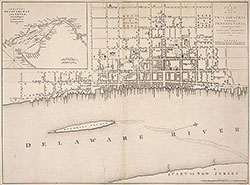
A Plan of the City of Philadelphia, the Capital of Pennsylvania, 1776, Map
Maps 1776: Benjamin Easburn, A Plan of the City of Philadelphia, The Capital of Pennsylvania
Item Info
Item No: MBEAAA00001
Title: A Plan of the City of Philadelphia, the Capital of Pennsylvania, 1776, Map
Additional Title: A Plan of the City of Philadelphia, the Capital of Pennsylvania, 1776
Publication Year:
1776
Page: 1
Work Type: General Maps
Source: Map Collection
Notes:
city almshouse: between 3rd & 4th Streets below Spring Street
city courthouse & Market: High Street between 2nd & 3rd Streets
city goal: sw corner of 3rd & Hight Streets
city workhouse: west side of 3rd Street below High Street
Loganian Library: west side of 6th above Walnut Street
Quaker almshouse: south side of Walnut Street below 4th Street
Notes:
inset: A Chart of the Delaware Bay and River from the Original by Mr. Fisher of Philadelphia, 1776
Northside Orientation of Image: Right
Alternate Page Number: Map
City/Town/Township: Geographic Coverage State/Province:Pennsylvania
Geographic Coverage City/Town/Township:Philadelphia
Geographic Coverage Neighborhood:Old City
Creator Name: Easburn, Benjamin - Surveyor
Dury, Andrew - Publisher
Andre, P. - Engraver
 Map
Map