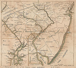
A Chorographical Map of the Country Round Philadelphia, 1778, Map
Maps 1778: Romans, A Chorographical Map of the Country Round Philadelphia
Item Info
Item No: MROMAA00001
Title: A Chorographical Map of the Country Round Philadelphia, 1778, Map
Additional Title: A Chorographical Map of the Country Round Philadelphia, 1778
Publication Year:
1778
Page: 1
Work Type: General Maps
Source: Map Collection
Notes:
Valley Forge encampment and tracks of Generals Washington and Howe. Published in New Haven
Northside Orientation of Image: Top
Alternate Page Number: Map
State: Geographic Coverage State/Province:Delaware
Geographic Coverage Note:Philadelphia environs
Creator Name: Romans, Bernard, 1741?-approximately 1784 - Cartographer
Subjects
 Map
Map