
Item Info
Item No: MTANAA00001
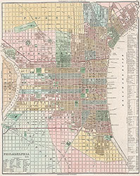
Title: Philadelphia, 1836, Map
Additional Title: Philadelphia, 1836
Publication Year:
1843
Page: 1
Work Type: General Maps
Source: Map Collection
Notes:
Plate 65 from Tanner's New Universal Atlas. First published in 1836, this map of Philadelphia is dated 1841 and was issued in the 1843 edition of the atlas. Includes location index to public buildings, churches, hotels and banks
Northside Orientation of Image: Right
Alternate Page Number: Map
City/Town/Township: Geographic Coverage State/Province:Pennsylvania
Geographic Coverage City/Town/Township:Philadelphia
Creator Name: Tanner, Henry Schenck, 1786-1858 - Publisher
Subjects
 Map
Map