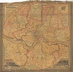
Map of the Circuit of Ten Miles Around the City of Philadelphia, 1847, Map
Maps 1847: Sidney, Map of the Circuit of Ten Miles Around the City of Philadelphia
Item Info
Page: 1
Work Type: Property Atlases/Maps
Source: Map Collection
Notes:
Arsenal Hotel: Tacony Road above U.S. Arsenal (PA: Philadlephia/Oxford)
Barton's Cotton Factory: Almonessing Creek above Blackwoodtown Road (NJ: Gloucester)
Black Horse Inn: Old Lancaster Road and County Line Road (PA: Montgomery/Lower Merion)
Blockelyville Hotel: West Chester Road below Gray's Lane (PA: Philadelphia/Blockely)
Boxer's Mill: Tacony Creek and Old York Road (PA: Montgomery/Cheltenham)
Bridesburg House: Bridesburg (Northern Liberties)
Briggs & Bro. Dark Run Mill: Lower Tacony Creek above Frankford Creek (PA: Philadelphia/Oxford)
Bristol Township Inn: McCartersville-kensington Turnpike below Green Lane (PA: Phila./Bristol)
Butchers and Drovers Tavern: Phila & Lancaster Turnpike & Haverford Street (PA: Phila./Blockely)
Buttermilk Tavern: Delaware River above Wissahickon Creek (PA: Philadelphia/Oxford)
Buttonwood Hotel: Germantown Road and Manheim Street (PA: Philadelphia/Germantown)
Buttonwood Tavern: Ridge Road at Greentree Lane (PA: Philadelphia/Roxborough)
Carr's Cotton Factory: Cresheim Creek at Cresheim Road (PA: Philadlephia/Germantown)
Carter's Factory: Indian Run above Haverford Road (PA: Philadelphia/Blockely)
Clapp & Greenwood's Factory: County Line Road below Old York Road (PA: Philadlephia/Bristol)
Collins' Factory: Indian Run below Haverford Road (PA: Philadelphia/Blockely)
Conrad's Mill: north branch of Newtown Creek (NJ: Camden/Newtown)
County Line Inn: Haverford Road and county line (PA: Philadelphia/Blockely)
Crease's Chemical Works: Green Lane above Gorgas Lane (PA: Philadelphia/Roxborough)
Crescentville Factory: Tacony Creek and Adams Road (Oxford)
Derringer's Mill: Mill Creek (PA: Montgomery/Lower Merion)
Donnelly's Mill: west side Schuylkill River opposite Manayunk (PA: Montgomery/Lower Merion)
Eagle Tavern: Germantown Road and Bethlehem Turnpike (PA: Philadelphia/Germantown)
Egbert's Mill: west side Schuylkill River opposite Roxborough (PA: Montgomery/Lower Merion)
Ely's Mill: Germantown Road and Wissahickon Creek (PA: Philadelphia/Germantown)
Farmers and Drovers Inn: Germantown Road at Trullinger'sLane (PA: Philadelphia/Germantown)
Farmers and Mechanics Inn: West Chester Road below Gray's Lane (PA: Philadelphia/Blockely)
Feltonville Hotel: Fishers Lane and Kensington Turnpike (PA: Philadelphia/Bristol)
Ferry Tavern: Schuylkill River and Penrose Ferry Road (PA: Philadelphia/Kingsessing)
Fisher's Wakefield Mills: Fishers Lane and Wingohocking Creek (PA: Philadelphia/Bristol)
Flatrock Inn: west side Schuylkill River opposite Roxborough (PA: Montgomery/Lower Merion)
Floyd's Mill: Mill Creek (PA: Montgomery/Lower Merion)
Fox Chase Inn: Elwood Lane & Philadelphia, Germantown & Perkiomen Pike (Northern Liberties)
Frankford Chemical Works: Frankford Turnpike and Harrowgate Lane near Roseville
Gable's Mill: Mill Creek (PA: Montgomery/Whitemarsh)
General Wayne Tavern: Lancaster Turnpike (PA: Montgomery/Lower Merion)
Germantown Poorhouse: Germantown Road at Poorhouse Lane (PA: Philadelphia/Germantown)
Golden Swan Hotel: Germantown Road above Rittenhouse Lane (PA: Philadelphia/Germantown)
Golden Swan Tavern: Schuylkill River and Passyunk Road (PA: Philadelphia/Passyunk)
Good Intent Woolen Mill: West Chester Road and Mill Creek (PA: Philadelphia/Blockely)
Gorgas Cotton Factory: Gorgas Lane and Wissahickon Creek (PA: Philadlephia/Roxborough)
Gray's Ferry Hotel: Gray's Ferry Road and Schuylkill River (PA: Philadelphia/Passyunk)
Greaves' Mill: Mill Creek (PA: Montgomery/Lower Merion)
Griffith's Factory: Little Tacony Creek above Frankford Creek (PA: Philadlephia/Oxford)
Haley's Dye Works: Gorgas Lane east of Ridge Road (PA: Philadelphia/Roxborough)
Hamburg Hotel: Schuylkill River above Beggarstown Lane (PA: Philadelphia/Passyunk)
Hammond's Mill: Tacony Creek below Mill Road (PA: Montgomery/Cheltenham)
Harper's Fork Factory: Shoemaker's Lane above Old York Road (PA: Philadlephia/Bristol)
Harrowgate Hotel: Harrowgate Lane above Frankford Road (Northern Liberties)
Hey's Factory: Darby Creek above Springfield Road (PA: Delaware/Springfield)
Howarth's Mill: Little Tacony Creek above Bustleton Turnpike (PA: Philadelpiha/Oxford)
Hunter's Factory: near Lancaster Turnpike above Hestonville
Hunter's Mill: near Lancaster Turnpike above Hestonville
Independent Farmers Inn: Kensington Turnpike and Elwood Lane (PA: Phila./Northern LIberties)
Inskeep's Mill: Muckinipaths Creek (PA: Delaware/Ridley)
Jones' Mill: Mill Creek (PA: Montgomery/Lower Merion)
Kelly''s Factory: Haverford Road at Cobb's Creek (PA: Delaware/Haverford)
Kellyville Mill: Darby Creek below Chadsford Road (PA: Delaware/Upper Darby)
Kingsessingville Inn: Darby Road above Warrington's Lane (PA: Philadelphia/Kingsessing)
Kulp's Mill: Tacony Creek below Washington Lane (PA: Montgomery/Cheltenham)
Lamb Tavern: Islington Lane and Ford Road (PA: Philadelphia/Penn)
Large's Dye Mill: Adams Road below Castor's Road (PA: Philadelphia/Oxford)
Lawrence's Mill: Darby Creek at Westchester Road (PA: Delaware/Haverford)
Lazaretto (old): Schuylkill River at Delaware River (PA: Philadelphia/Kingsessing)
Leedom's Mill: Cobb's Creek below Haverford Road (PA: Delaware/Haverford)
Leverington Hotel: Ridge Road above Green Lane (PA: Philadelphia/Roxborough
Levis' Mill: Darby Creek above Springfield Road (PA: Delaware/Upper Darby)
Lewis' Cotton Factory: Pennypack Creek below Bristol Turnpike (PA: Philadelphia/Lower Dublin)
Logan's Cotton Factory: Old York Road and Wingohocking Creek (Bristol)
Lower Dublin Hotel: Bustleton Turnpike and Mill Lane (PA: Philadelphia/Lower Dublin)
Mathew's Paper Mill: Darby Creek below Chadsford Road (PA: Delaware/ Upper Darby)
Matson's Mill: west side Schuylkill River opposite Manayunk (PA: Montgomery/Lower Merion)
Mayland's Mill: Mill Creek below Westchester Turnpike (PA: Philadelphia/Blockely)
Meadow Inn: Hollanders Creek (PA: Philadelphia/Moyamensing)
Morris' Mill: Mill Creek (PA: Montgomery/Lower Merion)
Myers' Mill: Tacony Creek and Church Road (PA: Montgomery/Cheltenham)
Nixon's Mill: Township Line Road above Cresheim Creek (PA: Philadlephia/Germantown)
Ogle's Mill: west side Schuylkill River opposite Manayunk (PA: Montgomery/Lower Merion)
Oxford and Dublin Poorhouse: Pennypack Creek above Bristol Turnpike (PA: Phila./Lower Dublin)
Passyunk Fish House: Schuylkill River below Gray's Ferry Road (PA: Philadelphia/Passyunk)
Passyunk Township Hotel: Passyunk Road and Long Lane (PA: Philadlephia/Passyunk)
Patterson's Factory: Cresheim Creek east of Township Line Road (PA: Philadelphia/Germantown)
Pennock's Grist and Spice Mill: Pennypack Creek below Bristol Turnpike (PA: Phila./Lower Dublin)
Pennypack Print Works: Pennypack Creek below Sandy Run (PA: Philadelphia/Lower Dublin)
Pilling's Print & Dye Works: Frankford Creek above Powder Mill Road (PA: Philadelphia/Frankford)
Piper's Mill: Wissahickon Creek at county Line (PA: Montgomery/Springfield)
Point Breeze Inn: Beggarstown Lane and Schuylkill River (PA: Philadelphia/Passyunk)
Point House: Greenwich Point Road and Delaware River (PA: Philadelphia/Moyamensing)
Powell's Saw Mill: east of Garrett and Radnor Roads (PA: Delaware/Upper Darby)
Red Lion Tavern: Lancaster Turnpike (PA: Montgomery/Lower Merion)
Ritchie's Mill: Mill Creek (PA: Montgomery/Whitemarsh)
Roberts' Mill: Pensauken Creek below Coles Road (NJ: Burlington)
Roberts' Mill: Tacony Creek below Church Road (PA: Montgomery/Cheltenham)
Robertson's Mill: Mill Creek (PA: Montgomery/Lower Merion)
Robinson's Mill: Wissahickon Creek at Ridge Road (PA: Philadelphia/Roxborough)
Robin Hood Tavern: Ridge Road below Heart Lane (PA: Philadelphia/Penn)
Rowland Bros. Mill: Tacony Creek below Shoemakertown (PA: Montgomery/Cheltenham)
Rowland Bros. Mill & Saw Factory: Wingohocking and Frankford Creeks (PA: Philadelphia/Bristol)
Roxborough Hotel: Ridge Road and Gorgas Lane (PA: Philadelphia/Roxborough)
Sans Souci: Schuylkill River and Gray's Ferry Road (PA: Philadelphia/Kingsessing)
Shallcross' Mill: Bristol Turnpike and Little Wissinoming Creek (PA: Philadelphia/Oxford)
Sheets' Mill: Darby Creek below Darby Borough (PA: Delaware/Darby)
Sheets' Mill: Mill Creek (PA: Montgomery County/Lower Merion)
Sheets' Mill: west side Schuylkill River opposite Manayunk (PA: Montgomery/Lower Merion)
Sheffield Oil Mill: Church Lane east of Germantown Road (PA: Philadelphia/Germantown)
Sorrel Horse Tavern: Burlington Road below Pensauken Creek (NJ: Camden/Delaware)
Sorrel Horse Tavern: Ridge Road above Ship Lane (PA: Philadelphia/Roxborough)
Sorrel Horse Tavern: Darby Road above Warrington's Lane (PA: Philadelphia/Kingsessing)
Spread Eagle Tavern: Horn Welsh Road & Stoys Landing Road (NJ: Camden/Delaware)
Spread Eagle Tavern: Westchester Road above Darby Creek (PA: Delaware/Haverford)
Spruce Mill: Wissahickon Creek and Spruce Mill Lane (PA: Philadelphia/Germantown)
Stevenson's Mill: north Branch Cooper's Cr. below Cooper's Road (NJ: Camden/Delaware)
Stoy's Mill: north branch of Newtown Creek (NJ: Camden/Delaware)
Stretcher's Brickyard: Mt. Ephram Road above Race Course Road (NJ: Camden/Newtown)
Thorp's Calico Print Works: Wissahickon Creek and Paul's Mill Lane (PA: Phila./Germantown)
Troth's Saw Mill: Cooper's Creek below Ellisburg Road (NJ:Camden/Delaware)
Union Tavern: Broad Street and Bond's Lane (PA: Philadelphia/Penn)
United States Hotel: 2nd Street Road below Tacony Creek (Bristol)
Washington Hotel: Haverford Road and Old Lancaster Road (PA: Philadelphia/Blockely)
Washington Tavern: Germantown Pike below 7th Street (PA: Philadelphia./Northern Liberties)
Washington Tavern: Ridge Road at Mifflin Lane (PA: Philadelphia/Penn)
Weatherill's Mill: west side Schuylkill River opposite Manayunk (PA: Montgomery/Lower Merion)
Wheat Sheaf Tavern: Bustleton Turnpike below Sandy Run (PA: Philadlephia/Lower Dublin)
Wheat Sheaf Tavern: Point No Point Road above Point Road (PA: Philadelphia/Northern Liberties)
Whitaker's Factory: Tacony Creek below Adams Road (Oxford)
White Horse Tavern: Southern Post Road above Darby Creek (PA: Delaware/Ridley)
Wister's Bleach Works: Wingohocking Creek below Township Line Road (PA: Philadelphia/Bristol)
Wittbank's Factory: Cobbs Creek Below Marshall's Road (PA: Philadelphia/Blockely)
Woodward's Snuff Mill: Chadsford Turnpike and Cobb's Creek (PA: Philadelphia/Blockely)
Northside Orientation of Image: Top Right
Alternate Page Number: Map
City/Town/Township: Geographic Coverage State/Province:New Jersey
Geographic Coverage City/Town/Township:Philadelphia
Geographic Coverage Region/County:Gloucester
Creator Name: Sidney, J. C. (James C.) - Engineer
Smith, Robert P. - Publisher
- Calico
- Philadelphia, Pennsylvania
- Taverns
- Hotels
- Montgomery County, Pennsylvania
- Camden County, New Jersey
- Delaware County, Pennsylvania
- Gloucester County, New Jersey
- Chemical plants
- Textile mills
- Paper mills
- Inns
- United States Hotel
- Oxford & Lower Dublin Poor House
- Sawmills
- Briggs & Bro. Dark Run Mill
- Whitaker, William-Cedar Grove Mill
- brickyards
- Cotton mills
- Washington Hotel
- Poorhouse see Almshouses (buildings)
- White Horse Tavern
- Crease's Chemical Works
- Bridesburg Hotel
- Hunter's Calico Print Works
- Germantown Poorhouse
- Pennock's Grist & Spice Mill
- Lower Dublin Hotel
- Crescentville Mills
- Large's Dye Mill
- Howarth's Mill
- Buttermilk Tavern
- Bristol Township Inn
- Pittsville Inn
- Roberts' Mill
- Drove Inn
- Farmers and Mechanics Inn
- Logan's Cotton Factory
- Thorp's Calico Print Works
- Spruce Mill
- Eagle Tavern
- Golden Swan Hotel
- Carr's Cotton Factory
- Farmers and Drovers Inn
- Buttonwood Hotel
- Buttonwood Tavern
- Roxborough Hotel
- Haley's Dye Works
- Gorgas Cotton Factory
- Leverington Hotel
- Robinson's Mill
- Robin Hood Tavern
- Unon Tavern
- Lamb Tavern
- Harrowgate Hotel
- Fox Chase Inn
- Meadow Inn
- Point Breeze Inn
- Hamburg Hotel
- Golden Swan Tavern
- Passyunk Township Hotel
- Passunk Fish House
- Gray's Ferry Hotel
- Lazarettos
- Ferry Tavern
- Sans Souci
- Kingsessingville Inn
- Butchers and Drovers Tavern
- County Line Inn
- Woodward's Snuff Mill
- Snyder's Spade Factory
- Good Intent Woolen Mill
- Blockelyville Hotel
- Ely's Mill
- Lewis' Cotton Factory
- Shallcross' Mill
- Point House
- Spread Eagle Tavern
- Troth's Saw Mill
- Stevenson's Mill
- Stretcher's Brick Yard
- Conrad's Mill
- Stoy's Mill
- Barton's Cotton Factory
- Innskeep's Mill
- Sheets' Mill
- Kellyville Mill
- Levis' Mill
- Mathew's Paper Mill
- Powell's Saw Mill
- Leedom's Mill
- Kelly's Factory
- Lawrence's Mill
- Hey's Factory
- Robertson's Mill
- Red Lion Tavern
- Black Horse Inn
- Matson's Mill
- Weatherill's Mill
- Donnelly's Mill
- Ogle's Mill
- General Wayne Tavern
- Flatrock Inn
- Morris' Mill
- Derringer's Mill
- Greaves' Mill
- Jones' Mill
- Floyd's Mill
- Gable's Mill
- Ritchie's Mill
- Piper's Mill
- Kulp's Mill
- Boxer's Mill
- Myers' Mill
- Hammond's Mill
- Arsenal Hotel
- Griffith's Factory
- County Line Inn
- Harper's Fork Factory
- Hurst's Mill
- Feltonville Hotel
- Clapp & Greenwood's Factory
- Wister's Bleach Works
- Wheat Sheaf Tavern
- Independent Farmers Inn
- Washington Tavern
- sheffield Oil Mill
- Patterson's Factory
- Nixon's Mill
- Rittenhouse Paper Mill
- Wittbank's Factory
- Mayland's Mill
- Carter's Factory
- Collins' Factory
- Waters' Factory
- Sorell Horse Tavern
- Frankford Chemical Works
- Landis' Retreat
- Morris' Dye Works
- Pilling's Print & Dye Works
- Fisher's Wakefield Mills
- Rowland Brothers Mill & Saw Factory
- Rowland Bros. Mill
- Pennypack Print Works
- Egbert's Mill
- Hunter's Mill
 Map
Map