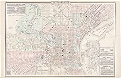
Railway Map of the State of Pennsylvania, 1872, map
Maps 1872: Gray, Railway Map of the State of Pennsylvania
Item Info
Item No: MGRAAA00001
Title: Railway Map of the State of Pennsylvania, 1872, map
Additional Title: Railway Map of the State of Pennsylvania, 1872
Publication Year:
1872
Page: 1
Work Type: Transportation Maps
Source: Map Collection
Notes:
from: New Topographic Atlas of the State of Pennsylvania by Henry F. Walling and O.W. Gray, Philadelphia, 1872, plates 32-33
Northside Orientation of Image: Top
Alternate Page Number: map
State: Geographic Coverage State/Province:Pennsylvania
Creator Name: Gray, Frank A. - Cartographer
Subjects
 Map
Map  list
list 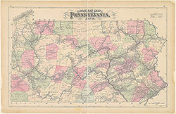 map
map