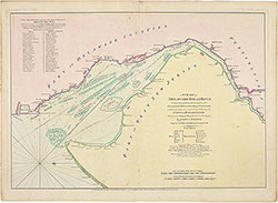
A Chart of Delaware Bay and River..., 1776, map
Maps 1776: Fisher, A Chart of Delaware Bay and River
Item Info
Item No: MFISAA00001
Title: A Chart of Delaware Bay and River..., 1776, map
Additional Title: A Chart of Delaware Bay and River..., 1776
Publication Year:
1776
Page: 1
Work Type: River/Ocean Navigational Charts
Source: Map Collection
Notes:
Cape May, Cape Hinlopen to Philadelphia
Northside Orientation of Image: Right
Alternate Page Number: map
State: Geographic Coverage State/Province:Pennsylvania
Creator Name: Fisher, Joshua, 1707-1783 - Publisher
Faden, William, 1749-1836 - Engraver
 map
map