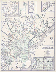
PRT Route Map Showing Streetcar, Bus and Subway-Elevated Lines [Philadelphia, PA], 1936, Map
Maps![PRT Route Map Showing Streetcar, Bus and Subway-Elevated Lines [Philadelphia, PA], 1936, Map](https://media.freelibrary.org/assets/digital/items/map00000022/images/large.jpg "Click to zoom in on this image")
Item Info
Item No: MAP00000022
Title: PRT Route Map Showing Streetcar, Bus and Subway-Elevated Lines [Philadelphia, PA], 1936, Map
Publication Year:
1936
Page: 22
Work Type: Transportation Maps
Source: Map Collection
Northside Orientation of Image: Top
Alternate Page Number: MAP
City/Town/Township: Geographic Coverage State/Province:Pennsylvnia
Geographic Coverage City/Town/Township:Philadelphia
Creator Name: Philadelphia Rapid Transit Compnay - Publisher
 MAP
MAP
 Directory