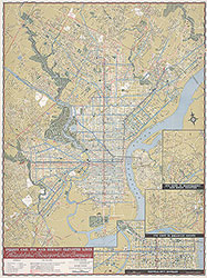
PTC Map of Philadelphia Showing Street Car, Bus and Subway-Elevated Lines, 1940, Directory
Maps
Item Info
Item No: MAP00000026
Title: PTC Map of Philadelphia Showing Street Car, Bus and Subway-Elevated Lines, 1940, Directory
Publication Year:
1940
Page: 26
Work Type: Transportation Maps
Source: Map Collection
Notes:
route numbers keyed to parks, sports centers, parking fields, office buildings, places of interest in central Philadelphia
Alternate Page Number: Directory
City/Town/Township: Geographic Coverage State/Province:Pennsylvania
Geographic Coverage City/Town/Township:Philadelphia
Creator Name: Philadelphia Transportation Company - Publisher
Subjects
 Map
Map 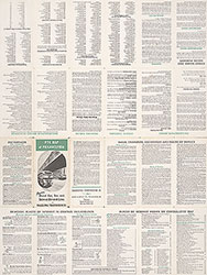 Directory