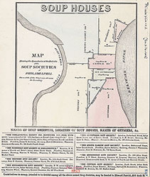
Soup Houses: Map Shewing the Boundaries of the Districts of the Soup Societies of Philadelphia, [1862?], Map
Maps![Soup Houses: Map Shewing the Boundaries of the Districts of the Soup Societies of Philadelphia, [1862?], Map](https://media.freelibrary.org/assets/digital/items/map00000078/images/large.jpg "Click to zoom in on this image")
Item Info
Item No: MAP00000078
Title: Soup Houses: Map Shewing the Boundaries of the Districts of the Soup Societies of Philadelphia, [1862?], Map
Page:
1
Work Type: Historical Divisions and Boundaries
Source: Map Collection
Notes:
Date is uncertain--in the margin it states "1921?" The map was acquired in 1927 from the Western Soup Society.
Notes:
Names of Soup Societies, location of Soup Houses, Names of Officers, &c.
Northside Orientation of Image: Top
Alternate Page Number: Map
City/Town/Township: Geographic Coverage State/Province:Pennsylvania
Geographic Coverage City/Town/Township:Philadelphia
Subjects
- Philadelphia, Pennsylvania
- Soup kitchens
- Philadelphia Soup House
- Northern Soup Society of Philadelphia
- Western Soup Society (Philadelphia, Pa.)
- Kensington Soup Society (Philadelphia, Pa.)
- Southwark Soup Society (Philadelphia, Pa.)
- Moyamensing Soup Society (Philadelphia, Pa.)
- Spring Garden Soup Society (Philadelphia, Pa.)
- Central Soup Society
 Map
Map