Map of the Park System of Philadelphia as it Existed in 1888 [and] 1915, 1915, Maps
Maps![Map of the Park System of Philadelphia as it Existed in 1888 [and] 1915, 1915, Maps](https://media.freelibrary.org/assets/digital/items/map00000092/images/large.jpg "Click to zoom in on this image")
Item Info
Page: 1
Work Type: Park Maps
Source: Map Collection
Notes:
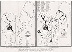
Below the maps it states: "The Parks of Philadelphia in 1888, When the City Parks Association was Formed." "The Parks of Philadelphia in 1915." "The City has done well in the acquisition of "Squares" and has begun moderately well in the creation of Playgrounds. While it has initiated the creation of an Outer Park System through the acquisition of a large part of the Pennypack valley for six miles and of the eastern side of Cobb's Creek valley for four miles, it lags far behind Boston. The Metropolitan Park System of that City covers over 16,000 acres. Philadelphia's Parks cover 6,000 acres. The population of Metropolitan Boston in 1910 was 1,520,470. The population of Metropolitan Philadelphia in the same year was 1,972,342. Metropolitan Boston has one-fourth less population than Metropolitan Philadelphia, but much more than twice its acerage of park land."
Notes:
Creation date for the 1915 system map is: 7/9/1915. Creation date for the 1888 system map is: 6/16/1915.
Northside Orientation of Image: Top
Alternate Page Number: Maps
City/Town/Township: Geographic Coverage State/Province:Pennsylvania
Geographic Coverage City/Town/Township:Philadelphia
Creator Name: Greene, Geo. M - Engineer
Philadelphia (Pa.) Bureau of Surveys - Publisher
 Maps
Maps