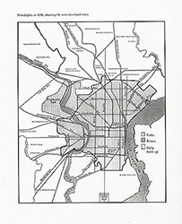
Philadelphia in 1896, Showing the Main Developed Areas, 1896, Map
Maps
Item Info
Item No: MAP00000095
Title: Philadelphia in 1896, Showing the Main Developed Areas, 1896, Map
Page:
1
Work Type: General Maps
Source: Map Collection
Notes:
The legend indicates: "Fully Built Up" areas, "Parks," and "Rivers."
Northside Orientation of Image: Top
Alternate Page Number: Map
City/Town/Township: Geographic Coverage State/Province:Pennsylvania
Geographic Coverage City/Town/Township:Philadelphia
 Map
Map
 Map
Map