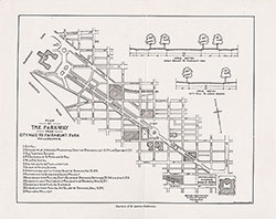
Plan of the Parkway From City Hall to Fairmount Park, Philadelphia, 1916, Map
Maps
Item Info
Item No: MAP00000106
Title: Plan of the Parkway From City Hall to Fairmount Park, Philadelphia, 1916, Map
Additional Title: 27th Annual Report of the City Parks Association of Philadelphia, 1916
Creation Date:
2/17/1916
Page: 1
Work Type: General Maps
Source: Map Collection
Notes:
27th Annual Report of the City Parks Association of Philadelphia
Notes:
Below the plan it states: "Courtesy of B. Antrim Haldeman."
Notes:
The initials "P.R.G. - G.M.G." are indicated in the bottom right corner of the plan.
Northside Orientation of Image: Top
Alternate Page Number: Map
City/Town/Township: Geographic Coverage State/Province:Pennsylvania
Geographic Coverage City/Town/Township:Philadelphia
Creator Name: Philadelphia (Pa.) Bureau of Surveys - Publisher
 Map
Map