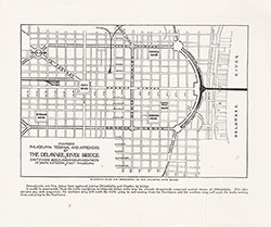
Proposed Philadelphia Terminal and Approaches of Delaware River Bridge, 1920, Map
Maps
Item Info
Item No: MAP00000108
Title: Proposed Philadelphia Terminal and Approaches of Delaware River Bridge, 1920, Map
Additional Title: 31st/32nd Annual Report of the City Parks Association of Philadelphia, 1920
Publication Year:
1920
Page: 1
Work Type: General Maps
Source: Map Collection
Notes:
Below the map it states: "Suggested Plan for Approaches to the Delaware River Bridge." "Pennyslvania and New Jersey have approved joining Philadelphia and Camden by bridge. It would uneconomic, from a traffic standpoint, to bring the bridge traffic into the already dangerously congested Central Streets of Philadelphia. This plan obviates any such congestion; the northern wing will catch the traffic going to and coming from the Northwest, and the southern wing will catch the traffic coming from and going to the Southeast."
Notes:
From the: 31st/32nd Annual Report of the City Parks Association of Philadelphia
Northside Orientation of Image: Top
Alternate Page Number: Map
City/Town/Township: Geographic Coverage State/Province:Pennsylvania
Geographic Coverage City/Town/Township:Philadelphia
Creator Name: Zantzinger, Borie, and Medary (Firm) - Architect
City Parks Association of Philadelphia - Publisher
 Map
Map