Plan of the City of Philadelphia and Environs, 1809, Map [Section 1 of 6]
Maps![Plan of the City of Philadelphia and Environs, 1809, Map [Section 1 of 6]](https://media.freelibrary.org/assets/digital/items/map00000171a/images/large.jpg "Click to zoom in on this image")
Item Info
Item No: MAP00000171a
Title: Plan of the City of Philadelphia and Environs, 1809, Map [Section 1 of 6]
Publication Year:
1809
Work Type: General Maps
Source: Map Collection
Notes:
The physical map is in 6 individual sections. Each section was scanned and assigned a unique image number ranging from MAP00000171a through MAP00000171f.
City/Town/Township: Geographic Coverage State/Province:Pennsylvania
Geographic Coverage City/Town/Township:Philadelphia
Geographic Coverage Region/County:Delaware
Creator Name: Hills, John, active 1777-1819 - Surveyor
Kneass, William, 1780-1840 - Engraver
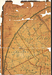 Plan of the City of Philadelphia and Environs, 1809, Map [Section 1 of 6]
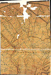 Plan of the City of Philadelphia and Environs, 1809 Map [Section 2 of 6]
 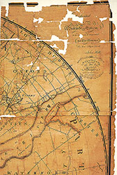 Plan of the City of Philadelphia and Environs, 1809, Map [Section 3 of 6]
 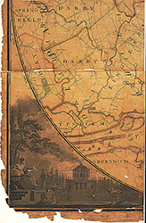 Plan of the City of Philadelphia and Environs, 1809, Map [Section 4 of 6]
 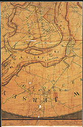 Plan of the city of Philadelphia and Environs, 1809, Map [Section 5 of 6]
 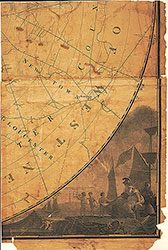 Plan of the city of Philadelphia and Environs, 1809, Map [Section 6 of 6]