Amérique du Nord [North America], 1879, map
Maps![Amérique du Nord [North America], 1879, map](https://media.freelibrary.org/assets/digital/items/map00000223/images/large.jpg "Click to zoom in on this image")
Item Info
Item No: map00000223
Title: Amérique du Nord [North America], 1879, map
Publication Year:
1879
Work Type: General Maps
Source: Map Collection
Notes:
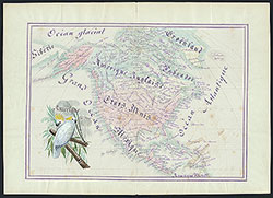
Manuscript map in pen-and-ink and watercolor, drawn by a schoolgirl in Elbeuf, France. Text in French.
Includes North America and portions of Central America, Siberia, and Greenland, with names of states, territories, cities, etc. Identifies Indigenous nations in some regions.
Includes vignette of two parrots on a tree branch. Cartographer signature, place, and date of publication faintly visible in tree branches.
Northside Orientation of Image: Top
Creator Name: Demicule, Marie - Cartographer
 Amérique du Nord [North America], 1879, map