A Map of the World, 1816, map
Maps
Item Info
Item No: map00000225
Title: A Map of the World, 1816, map
Publication Year:
1816
Work Type: General Maps
Source: Map Collection
Notes:
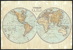
Manuscript map in pen-and-ink and watercolor, drawn by a schoolgirl.
A hand drawn world map on hemispheric projection split into western and eastern hemispheres, depicting countries, capitals, port cities, nautical exploration routes, rivers, mountains, etc. Indigenous nations identified in some regions.
Includes "Equinoctial line" and "The Zodiac" line.
"Drawn and painted at Lynn Academy."
Creator Name: Phillips, Phebe - Cartographer
 A Map of the World, 1816, map