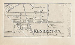
Kenderton, 1861, Map
Maps
Item Info
Item No: MAP00000081
Title: Kenderton, 1861, Map
Additional Title: Map of the Vicinity of Philadelphia, from Actual Surveys, 1861
Publication Year:
1861
Page: 1
Work Type: Property Atlases/Maps
Source: Map Collection
Notes:
From: Map of the Vicinity of Philadelphia, from Actual Surveys, 1861. See digital ID number: MLBPAA00004a
Northside Orientation of Image: Top
Alternate Page Number: Map
City/Town/Township: Geographic Coverage State/Province:Pennsylvania
Geographic Coverage City/Town/Township:Philadelphia
Geographic Coverage Neighborhood:Kenderton
Creator Name: Lake, D. J. - Surveyor
Beers, S. N. - Surveyor
J.E. Gillette & Co. - Publisher
Beers, D. G. (Daniel G.) - Surveyor
Beers, F. W. (Frederick W.) - Surveyor
Lake, L. B. - Surveyor
Subjects
 Map
Map