Map of the Vicinity of Philadelphia From Actual Surveys 1861, Plate 3-A: Philadelphia (part)
Maps 1861: Map of the Vicinity of Philadelphia, from Actual Surveys
Item Info
Page: 5
Work Type: Property Atlases/Maps
Source: Map Collection
Notes:
Allen Grove Female Seminary: Cedar Street below Wakeling Street (Frankford)
Aramingo Cotton Factory: Frankford Creek above Philadelphia & Trenton Railroad (Frankford)
Banes and Wilens Bone Mill: Margaret and Bermuda Streets (Frankford)
Borie & Mackie Stick Factory:Oxford and Tackawanna Streets (Frankford)
Castor's Coach and Carriage Factory: Frankford Street above Allen Street (Frankford)
Eagle Hotel: Frankford Street below Ruan Street (Frankford)
Fairmount Fork Works: Frankford Creek at Ashland Street (Frankford)
Faunce's Hotel: Frankford Street above Green Street (Frankford)
Fourth Division Hotel: Frankford Street below Foulkrod Street (Frankford)
Fritsch's Brewery: Edward Street below Ruan Street (Frankford)
Generall Pike Hotel: Frankford Street above Pike Street (Frankford)
Hayes & Ellis Steam Planing Mill: Frankford Street below Arrott Street (Frankford)Horrocks' Frankford Dye Works: Between Adams and Orthodox Streets above Oakland Street (Frankford)
Keystone Iron Works: Little Tacony Creek at Mulberry Street (Frankford)
Oddfellows Hall:Frankford Street above Green Street (Frankford)
Post Hotel: FRankford Street above Edward Street (Frankford)
Rowland Bros. Oxford Iron & Steel Works: Frankford Creek above Ashland Street (Frankford)
Shallcross Bone Mill: Tucker and Pierce Streets (Frankford)
Tacony Print Works: Little Tacony Creek below Orchard Street (Frankford)
Wingohocking Mills: Frankford Creek at Ashland Street (Frankford)
Notes:
Includes inset maps of various Philadelphia neighborhoods. Includes Frankford and Germantown Business Directories.
Northside Orientation of Image: Top
Alternate Page Number: Plate 3-A: Philadelphia
City/Town/Township: Geographic Coverage State/Province:Pennsylvania
Geographic Coverage City/Town/Township:Philadelphia
Geographic Coverage Neighborhood:Germantown (part)
Creator Name: Lake, D.J. - Surveyor
Beers, S. N. - Surveyor
J.E. Gillette & Co. - Publisher
Beers, D. G. (Daniel G.) - Surveyor
Beers, F. W. (Frederick W.) - Surveyor
Lake, L. B. - Surveyor
- Carriages & coaches
- Philadelphia, Pennsylvania
- Iron industry
- Hotels
- Eagle Hotel
- Schools
- Pitchforks
- Germantown
- Frankford
- Wingohocking Mills
- Assembly halls
- Breweries
- Textile mills
- Steel mills
- Hayes, Ellis & White Planing Mill
- Planing mills
- Aramingo Mills
- Rowland, William & Harvey Oxford Iron & Steel Works
- Forks (agricultural tools)
- Oddfellows Hall
- Allen Grove Female Seminary
- Shallcross' Mill
- Frankford Dye Works (J. & W. Horrocks)
- Keystone Iron Works
- Banes & Wilens Bone Mill
- Fairmount Fork Works
- Tacony Print Works
- Borie & Mackie Stick Factory
- Faunce's Hotel
- Fourth Division Hotel
- Post Hotel
- General Pike Hotel
- Castor's Coach and Carriage Factory
- Fritsch's Brewery
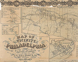 Plate 2-A: Philadelphia
 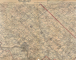 Plate 2-B: North Suburbs
 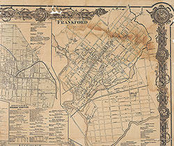 Plate 3-A: Philadelphia
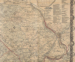 Plate 3-B: Northeast Suburbs
 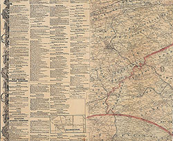 Plate 4-A: Southwest Suburbs
 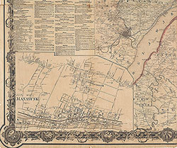 Plate 4-B: Southeast Suburbs
 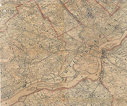 Plate 5-A: South Suburbs
 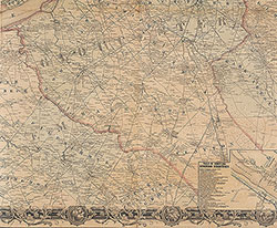 Plate 5-B: South Suburbs
 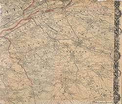 Plate 6-A: Southeast Suburbs
 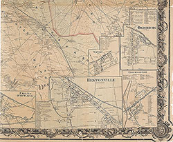 Plate 6-B: Southeast Suburbs
 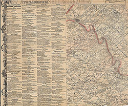 Plate 1-B: Northwest Suburbs
 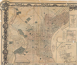 Plate 1-A: Philadelphia