Map of the Vicinity of Philadelphia, From Actual Surveys, 1861, Plate 6-B: Southeast Suburbs
Maps 1861: Map of the Vicinity of Philadelphia, from Actual Surveys
Item Info
Page: 12
Work Type: Property Atlases/Maps
Source: Map Collection
Notes:
Avenue Drove Yard Hotel: Lancaster Avenue and Belmont Avenue (Hestonville)
Blue Bell Hotel: Darby Avenue and Island Road (Paschallville)
Boyle Hotel: Lancaster Avenue and Markoe Street (Hestonville)
Dobson's Mills: Scott's Lane above Ridge Avenue (Falls of Schuylkill)
Falls Hotel: Ridge Avenue above Scott's Lane (Falls of Schuylkill)
Hunter Print Works: Mill Creek and Paschall Street (Hestonville)
Lodge Cotton Factory: River Street and Pennypack Creek (Holmesburg)
Monroe Engine House: Lancaster Avenue above Cambria Street (Hestonville)
Railroad Hotel: Ridge Avenue above Scott'sLane (Falls of Schuylkill)
Rising Sun Hotel: Lancaster Avenue below Cathedral Street (Hestonville)
St. Vincent's Orphan Asylum: St. Vincent Street and Delaware River (Tacony)
Suplee Mills: Mill Creek and Apple Street (Hestonville)
Tacony Hotel: Penn Street and Delaware River (Tacony)
Union Drove Yard Hotel: Lancaster Avenue and Belmont Avenue (Hestonville)
Union Public Hall: Indian Queen Lane above Ridge Avenue (Falls of Schuylkill)
Vandergrift's Hotel: Penn and Queen Streets (Tacony)
Washington Hotel: Washington Street and Delaware River (Tacony)
Washington House: Main Street below Mill Street (Holmesburg)
Yewdall's Woolen Factory: Mill Creek below Torr Avenue (Hestonville)
Notes:
Includes inset maps of various Philadelphia neighborhoods. Includes Business Directories for Hestonville, Holmesburg, Paschallville and Tacony.
Northside Orientation of Image: Top
Alternate Page Number: Plate 6-B: Southeast Suburbs
County: Geographic Coverage State/Province:New Jersey
Geographic Coverage City/Town/Township:Philadelphia
Geographic Coverage Neighborhood:Tacony
Geographic Coverage Region/County:Gloucester (part)
Creator Name: Lake, D.J. - Surveyor
Beers, S. N. - Surveyor
J.E. Gillette & Co. - Publisher
Beers, D. G. (Daniel G.) - Surveyor
Beers, F. W. (Frederick W.) - Surveyor
Lake, L. B. - Surveyor
- Calico
- Carpets
- Philadelphia, Pennsylvania
- Wool industry
- Hotels
- Camden County, New Jersey
- Holmesburg
- Gloucester County, New Jersey
- Tacony
- East Falls
- Fire stations
- Assembly halls
- Textile mills
- Hestonville
- Paschallville
- Falls of Schuylkill Carpet Mills (J.& J. Dobson)
- St. Vincent Orphanage (asylum)
- Rising Sun Hotel
- Washington House
- Cotton mills
- Washington Hotel
- Railroad Hotel
- Monroe Engine Company
- Hunter's Calico Print Works
- Lodge Cotton Factory
- Union Public Hall
- Falls Hotel
- Yewdall's Woolen Factory
- Suplee Mills
- Boyle Hotel
- Avenue Drove Yard Hotel
- Union Drove Yard Hotel
- Blue Bell Hotel
- Vandergrift's Hotel
- Tacony Hotel
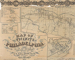 Plate 2-A: Philadelphia
 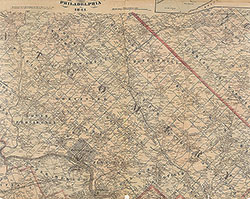 Plate 2-B: North Suburbs
  Plate 3-A: Philadelphia
 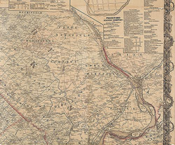 Plate 3-B: Northeast Suburbs
 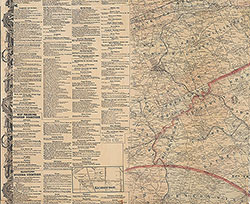 Plate 4-A: Southwest Suburbs
 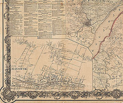 Plate 4-B: Southeast Suburbs
 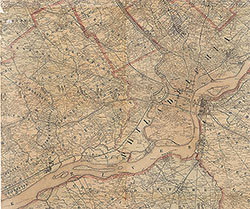 Plate 5-A: South Suburbs
 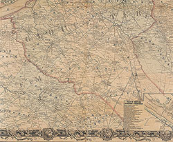 Plate 5-B: South Suburbs
 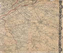 Plate 6-A: Southeast Suburbs
 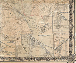 Plate 6-B: Southeast Suburbs
 Plate 1-B: Northwest Suburbs
  Plate 1-A: Philadelphia