Map of the Whole Incorporated City of Philadelphia, 1867, Plate 5
Maps 1867: Barnes, Map of the Whole Incorporated City of Philadelphia
Item Info
Page: 6
Work Type: Street Maps
Source: Map Collection
Notes:
Academy of Music: southwest corner Broad & Locust Streets
Academy of Natural Sciences: northwest corner Broad & Sansom Streets
American Sunday School Union: 11th Street to 12th Street between Chestnut & Sansom Streets
Arch Street Railway Station: south side Callowhill Street below the wire bridge
Assembly Building: west side 10th Street below Chestnut Street
Athenaeum of Philadelphia: east side 6th Street below Walnut Street
Belmont Petroleum Refinery: west side Schuylkill River, Bridgewater St. above Columbia Bridge
Bement & Dougherty Industrial Works: north side Callowhill Street between 20th & 21st Streets
Blockely Almshouse: west side Schuylkill River below Woodland Street
Bolton & Dykeman & Co. Car Works: Pennsylvania Avenue & 22nd Street
Bush Hill Iron Works (Matheus & Moore): south side Spring Garden St. bet. 16th & 17th Streets
Classical Institute: northwest corner 12th & Chestnut Streets
Continental Theatre: west side 8th Street between Walnut & Sansom Streets
Delaware Reservoir: northeast corner 7th Street & Lehigh Avenue
Eastern Market: east side 5th Street below Market Street
Eastern State Penitentiary: noth side Fairmount Avenue between Corinthian & 22nd Streets
Fairmount Dye Works24th & Callowhill Streets
Fairmount Market: southwest corner Spring Garden & 22nd Streets
Fairmount Print Works: south side Callowhill Street at 25th Street
Franklin Institute: east side 7th Street below Market Street
Franklin Market: east side 12th Street above Market Street
Girard Avenue Railway Station: west Side Minor Street below Girard Avenue
Girard Bank: west side 3rd Street belwo Chestnut Street
Green & Coates Street Railway Station: south side Coates Street between 24th $ 25th Streets
Horstmann's Manufactory: Cherry to Race Streets between 4th & 5th Streets
House of Industry School: southwest corner 7th & Catharine Streets
House of Refuge: Parish Street to Poplar Street between 22nd & 24th Streets
Lancaster Passenger Railway Station: Woodland Street at 33rd Street
Lombard & South Street Railway Station: northwest corner 25th & South Streets
Magdalen Society: east side 21st Street above Race Street
Maupay's Nursery: Broad & Allegheny Streets
McKeone & Van Haagen Soap Works: south side Callowhill Street below the wire bridge
Moyamensing Hall: south side Christian Street below 10th Street
Murphy & Allison Junction Car Works: south side Walnut Street below Mansion Street
National Hall: south side Race Street below 6th Street
Norris Locomotive Works: south side Buttonwood between 16th & 17th Streets
Northern Home For Friendless Children: Brown St. to Parrish St. between 22nd & 23rd Streets
Oddfellows Hall: west side 6th Street above Cherry Street
Oram & Co. Iron Works: south side Buttonwood Street between 15th & 16th Streets
Park Hotel: Pennsylvania Avenue, Brown & 29th Street
Parrish's Factory: northwest corner 33rd & Chestnut Streets
Pennsylvania Institute For the Deaf & Dumb: northwest corner Broad & Pine Streets
Pennsylvania Institute For the Instruction of the Blind: west side 20th Street above Race Street
Pennsylvania Railroad Station: north side Market Street above 30th Street
Pennsylvania State Arsenal: southeast corner 16th & Filbert Streets
Potter Oil Cloth Factory: south side Spring Garden between 17th & 18th Streets
Powers & Weightman Chemical Works: East Falls
St. Joseph's Hospital: south side Girard Avenue between 16th & 17th Streets
Sauders Institute: 39th Street above Filbert Street
Seamens Friends' Society: northwest corner Front & Lombard Streets
Setter's Match Works: south side Hamilton Street between 16th & 17th Streets
Sharp & Hankins Firearms Factory: east side 24th Street above Green Street
Southwark Hose Co.: west side 3rd Street below Lombard Street
Spring Garden Gas Works: south side Callowhill Street at 25th Street
Spring Garden & Northern Liberties Waterworks: Pennsylvania Avenue below Girard Avenue
Union Drove Yard: Pennsylvania Railroad tracks east of 32nd Street
Union Railway Station: west side 23rd Street below Brown Street
United States Mint: northwest corner Junioer & Chestnut Streets
United States Naval Hospital: southeast corner Shippen Street & Humes Avenue
United States Quartermaster: east side 12th Street below Market Street
Walnut Street Theatre: northeast corner 9th & Walnut Streets
Washington Engine Co.: north side Lombard Street below 11th Street
West Chester Railroad Station: south side Market Street above 30th Street
West Philadelphia Fire Engine Co.: north side Market Street above 34th Street
West Philadelphia Institute: 39th Street above Filbert Street
West Philadelphia Water Works: west side Schuylkill River below Westminster Street
Whitney & Sons Car Wheel Works: south side Pennsylvania Ave. between 16th & 17th Streets
Wills Hospital: south side Race Street above 18th Street
Wood, William & Co. Woolen Mill: northwest corner 24th & Hamilton Streets
Northside Orientation of Image: Top
Alternate Page Number: Plate 5
City/Town/Township: Geographic Coverage State/Province:Pennsylvania
Geographic Coverage City/Town/Township:Philadelphia
Creator Name: Barnes, Rufus L. - Publisher
Hexamer, Ernest - Surveyor
- McKeone, Van Haagen & Co.
- Oilcloth
- Philadelphia, Pennsylvania
- Powers & Weightman
- Railroad stations
- Soap
- Street railroads
- Waterworks
- Wheels
- Old United States Mint
- Iron industry
- Railroads
- Wool industry
- Petroleum industry
- Firearms industry
- Matches
- Gas industry
- Hotels
- Banks
- Markets
- Academy of Natural Sciences of Philadelphia
- Academy of Music
- Music halls
- Theaters
- Dance halls
- Mints
- Reservoirs
- Western Market
- Walnut Street Theatre
- Hospitals
- Pennsylvania State Arsenal
- Pennsylvania Railroad Station
- Schools
- Orphanages
- Streetcars
- Deaf persons
- Pennsylvania Institution for the Deaf and Dumb
- Classical Institute
- Military hospitals
- Fire stations
- Street railroad stations
- Magdalen Society
- Pennsylvania Institute for the Instruction of the Blind
- Assembly halls
- Wills Hospital
- Chemical plants
- Locomotives
- Fairmount Market
- House of Refuge
- Eastern Market
- Franklin Market
- Arsenals
- West Chester Railroad Station
- Eastern State Penitentiary
- Textile mills
- Farmers' markets
- Market houses
- Science museums (buildings)
- Northern Home for Friendless Children (Philadelphia, Pa.)
- Reformatories (buildings)
- Asylums (welfare buildings)
- St. Joseph's Hospital
- Athenaeums
- Almshouses (buildings)
- Blind-Institutional Care
- Horse railroads
- Fairmount Dye Works (Clough & Carson)
- American Sunday School Union
- Prostitution
- Eye hospitals
- Prostitutes
- Potter, Thomas, Son & Co. Oil Cloth Works
- Assembly Building
- Oddfellows Hall
- Whitney & Sons Car Wheel Works
- Oram, H.W. Iron Works
- Norris, Richard & Son Locomotive Works
- Bush Hill Iron Works (Matheus & Moore)
- Bement & Dougherty Iron Works
- Green and Coates Street Railroad Station
- Park Hotel
- National Hall
- Penitentiaries (buildings)
- House of Industry
- Moyamensing Hall
- Southwark Hose Company
- Arch Street Railway Depot
- Spring Garden Gas Works
- Union Drove Yard and Hog Market
- Nurseries (horticulture)
- Saunders Institute
- West Philadelphia Institute
- Blockely Almshouse
- West Philadelphia Water Works
- Girard Avenue Passenger Railway Depot
- Delaware Reservoir
- West Philadelphia Fire Engine Company
- Pennsylvania Seaman's Friend Society
- Lombard & South Streets Railway
- American Academy of Music see Academy of Music
- Franklin Institute
- Horstmann's Manufactory
- Maupay's Nursery
- Athenaeum of Philadelphia
- Continental Theatre
- Parrish's Factory
- United States Quartermaster
- Setters' Match Works
- Bolton & Dykeman Co. Car Works
- Sharp & Hankins Firearms Factory
- Union Railway Station
- Wood, William & Co. Woolen Mill
- Fairmount Print Works
- Belmont Petroleum Refinery
- Lancaster Passenger Railway Station
- Murphy & Allison Junction Car Works
- Spring Garden & Northern Liberties Waterworks
- Washington Engine House
- Girard Bank
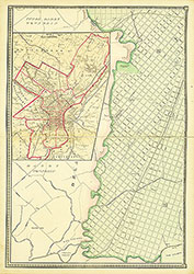 Plate 3
 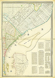 Plate 4
 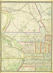 Plate 5
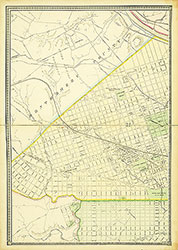 Plate 6
  Cover
Cover 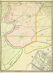 Plate 2
 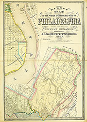 Plate 1