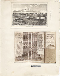
Castner Scrapbook v.7, Walks, Views, Maps, page 2
Historical Images of Philadelphia Castner Scrapbook Collection
Item Info
Historic Street Address: 5th & Walnut Streets
Historic Street Address: 7th & Race Streets
Media Type: Scrapbooks
Source: Print and Picture Collection
Notes:
Item pdcc00573, top left [image dimensions 10.1 cm x 15.4 cm]:
http://historicphiladelphia.org/franklin-square/what-to-see/
Depicts the fountain display in leafy Franklin Square - one of Philadelphia's five original squares - surrounded by crowds enjoying the spectacle. In the foreground are several groups of women and children. Two ladies with parasols and a man with a walking stick stroll on the stone ledge surrounding the pool.
Notes:
Item pdcc00574, top right [image dimensions 7.6 cm x 7.4 cm]:
http://historicphiladelphia.org/franklin-square/what-to-see/
View of fountain display in Franklin Square, one of the five original squares laid out by William Penn in his design for the city.
Notes:
Item pdcc00575, middle left [image dimensions 8.4 cm x 7.5 cm]:
http://historicphiladelphia.org/franklin-square/what-to-see/
View of fountain display at Franklin Square, one of the five original public squares in William Penn's design for the city.
Notes:
Item pdcc00576, bottom left [image dimensions 9.5 cm x 13.1 cm]:
http://www.nps.gov/inde/index.htm
Depicts the rear of Independence Hall, as seen through the winter trees lining the paths in Independence Square. Several people are shown strolling the grounds.
Notes:
Item pdcc00577, middle right [image dimensions 10.5 cm x 17.2 cm]:
http://philadelphiaencyclopedia.org/archive/civil-war-sanitary-fairs/
Depicts the Great Central Fair in aid of the U. S. Sanitary Commission, in Logan Square, June 1864. The thoroughfares which form the extreme foreground are Nineteenth and Vine Streets. The door facing this intersection is at the northwest corner of the Square, and the perspective sweeps in a southerly and eastwardly direction over the roofs and spires of the city. The great cathedral basilica of SS Peter & Paul looms up in the background on the left hand side of the picture.
Notes:
Item pdcl00062, bottom right [image dimensions 7.5 cm x 7.6 cm]:
"In the foreground of this view from the State House toward the Delaware River is the original Library Hall. This building, which has housed Franklin's Library Company, was taken down in 1888 to give space for an office building. In 1956 the site was cleared again and the Library Hall was rebuilt in its old location for the American Philosophical Society. At the extreme left center in the photograph is the white rooftop of the Second Bank of the United States, and just above it Carpenter's Hall. In the center (middle distance) rises the cupola of the Merchants' Exchange. The area seen here is now part of Independence National Historic Park."--OPEP, p. 67.
Aerial view from the State House facing the Delaware river. In the foreground, Library Hall viewed through trees. Also visible part of the Second Bank of the United States, Carpenter's Hall and the cupola of the Merchants' Exchange Building. Commercial buildings include: "Inquirer Printing Office" ; Hardings Bible Manufactory" ; "Safet ... [Man]ufactory" ; "Evans Card Printing" ; "Library Street..." ; "Goldsmiths Hall".
Building demolished: YES
Bibliography:
Item pdcl00062: Reprinted in: Old Philadelphia in early photographs, 1839-1914/edited by Robert F. Looney. New York: Dover Publications, c1976.
Geocode Latitude: Geocode Longitude:-75.171775
Geocode Latitude:39.960021
Call Number: A917.481 P536 v.7
Creator Name: Castner, Samuel, Jr., 1843-1929 - Compiler
Schell, Frederic B. - Engraver
Rea, J. - Artist
- Fountains
- Independence Hall
- Libraries
- Trees
- Cathedral Basilica of SS. Peter and Paul
- Logan Square
- Great Central Fair for the United States Sanitary Commission
- People
- Tents
- Delaware River Front
- Delaware River
- Rivers
- Commercial buildings
- Merchants' Exchange Building
- American Philosophical Society
- Bank of the United States (1816-1836)
- Carpenters' Hall
- Inquirer Printing Office
- Hardings Bible Manufactory
- Evans Card Printing
- Goldsmiths Hall
- Library Company of Philadelphia
- Parks
- Franklin Square
- Play (recreation)
- Independence Square
- Parasols
- Historic parks
- Fairs
 53
53 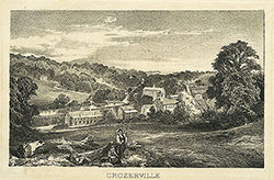 1B
1B  1B
1B  1C
1C 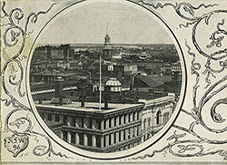 1C
1C  1C
1C  0
0  1B
1B 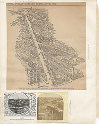 1C
1C  2
2  2
2 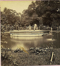 2
2 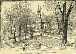 2
2 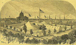 2
2  3
3  11
11  11
11  14
14  14
14  15
15  15
15  16
16  17
17  17
17  18
18  19
19  19
19  20
20  21
21 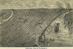 22
22 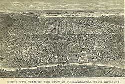 22
22  38
38 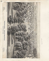 42
42  31
31  43
43  34
34  43
43  43
43  18
18  1
1 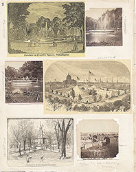 2
2
 3
3 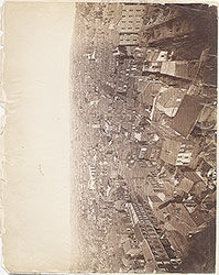 4
4  5
5  6
6 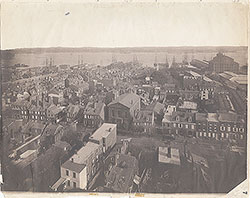 7
7 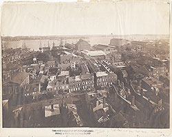 8
8 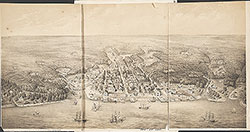 9
9  10
10  11
11  13
13  14
14  15
15  18
18  19
19  20
20  21
21  22
22  23
23 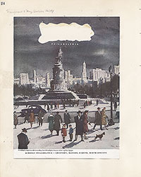 24
24  25
25  26
26  28
28  31
31  32
32 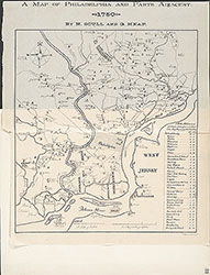 33
33  34
34  35
35  36
36  37
37  38
38  39
39 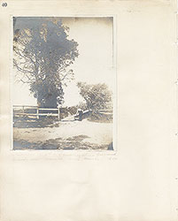 40
40  43
43  43
43  44
44  45
45  46
46 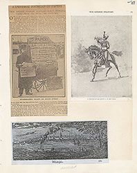 47
47  17
17 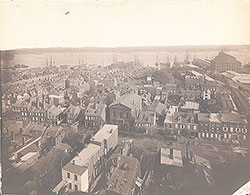 7
7  8
8 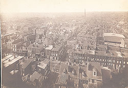 6
6 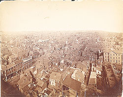 4
4 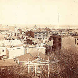 2
2  47
47 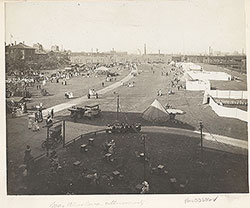 53
53  53
53 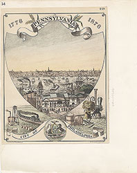 54
54  53
53  55
55  56
56  57
57  49
49  50
50  51
51  52
52  57
57  58
58 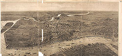 59
59 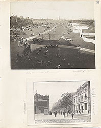 53
53  63
63 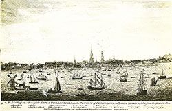 64
64 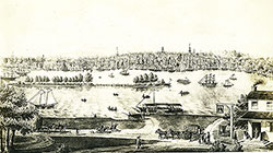 64
64 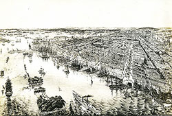 65
65  67
67 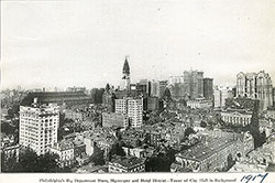 67
67  68
68  70
70  69
69  69
69 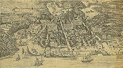 71
71  72
72  74
74  57
57  57
57  57
57  57
57  57
57  57
57 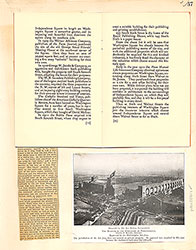 57
57  57
57  60
60  61
61  62
62  63
63  64
64 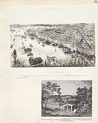 65
65 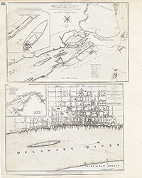 66
66 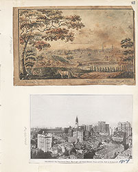 67
67  68
68 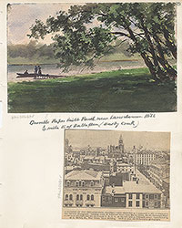 69
69 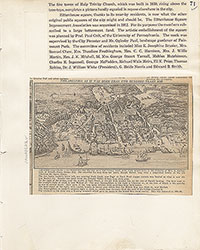 71
71  73
73  74
74  75
75  76
76  77
77  78
78  79
79  79
79 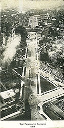 80
80  80
80 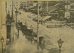 80
80  84
84  85
85  85
85  86
86  86
86  91
91  93
93  97
97  76
76  78
78  79
79  80
80  81
81  82
82  83
83  84
84  85
85  86
86  87
87  88
88  89
89  90
90  91
91  92
92  93
93  94
94  00
00  97
97  97
97  97
97  97
97  97
97  97
97  97
97  97
97 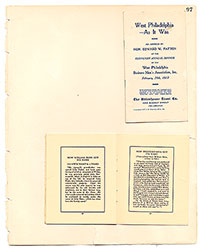 97
97  97
97  12
12  27
27  29
29  30
30  41
41  77
77  95
95  96
96 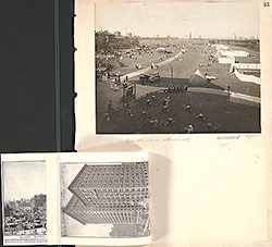 53
53  43
43  43
43  57
57